Well this is it!!!

Here it is. The big day. The chance to present my project in front of my friends, family, and community members. I’m very excited about this and I hope you all are too.

DSCF4554
Please join us on Wednesday, June 15th, 2016 at 12:00pm. The presentation will be held at the Dorchester County Historical Society at 1003 Greenway Drive, in Cambridge, Maryland, 21613.

I look forward to seeing you there!

DSCF4104


DSCF5074

A Public Presentation…

Well it is that time of year. It is almost time to start collecting new sites and I look forward to new and interesting locations and photos to be able to share with you. The most exciting thing I have to share right now is that we have been invited to speak at the Dorchester County Historical Society and I finally have a date for that to share with you.

The presentation will be held on June 15th, 2016 at 12:00pm (bring your lunch!). It will be held at the Dorchester Historical Society Building at 1003 Greenway Drive, Cambridge, Maryland, 21613.

DCHSMap

I would like to extend an invitation to everyone who has been reading along and sending in locations, and supporting us throughout this project. I couldn’t have done this without all of the help from tips coming in through email and spotters keeping lists of sites they see while driving, and the guides for taking me to some of the more remote parts of the county. I would love to see you all there and be able to thank you in person.

20151125_121813

Remember to keep those tips coming in! There are just some graves that we could never find without your help!

Anyone going out now working on their own research remember, Spring has Sprung. Make sure you use bug repellent, I’ve already heard reports of ticks, chiggers, and mosquitoes. I have also seen some snakes while I was out, so be safe and make sure you keep an eye on your surroundings.

20160417_163138

Spring is in the Air…

And Happy Easter Weekend to everyone. I just wanted to bring everyone up to date on what’s going on! We had a fantastic time at the TUgis Conference. The presentation went beautifully and was very well received. There was a lively Q&A and discussion afterwards and many agencies, organizations, and individuals were interested in helping out or volunteering in some way. I hope to be able to reach out to people soon with some volunteering ideas. Also the Dorchester Graves Webmap won the award for Best Student WebApp, so that is very exciting (thank you everyone who voted for us!).

I’d like to thank everyone who came to the TUgis presentation or stopped by the WebApp Hall to visit and talk. It was exciting to get to meet some of the blog readers and followers in person. Thank you all for the kind words and support!

20160315_134343

Also we have been invited to speak at the Dorchester County Historical Society and give a presentation on our project and its findings. It will be mostly geared towards individuals who are doing historical or genealogical research with a little section regarding the science and technology of data collection, but anyone interested in the project is more than welcome to attend. There will be more information to follow on that once we have the details nailed down.

The Salisbury University Geography Department has been kind enough to let me use the GPS device this spring even though I am no longer a student, so I hope to start collecting points again next month. If you know of a gravesite that is not currently represented on the map (click here to go to map) please email us so we can put your site on the list of places to visit.

20160114_171736

Additionally I have been adding the rest of the photo’s to the website. The link for every sites name, alphabetically up to letter “H”, should be in good working order. If you find a link between A-H that is broken, or just leads back to the map instead of to the correct photo page, please email me and let me know so I can fix it. I am slowly but surely plugging away at this so thank you for your patience.

I believe that is all the news I have for now. I know I haven’t been posting as frequently as usual but until collection resumes there just isn’t as much excitement to talk about. I promise once I start fieldwork again there will be more photos and more to read about. But until then please enjoy this photo of the full moon from Wednesday night that I took through my telescope!

20160324_011531

By the Book

The question that has been popping up the most here recently is “How did you know they were here?” I’ve mentioned before that I use various methods including interviews with locals, old maps, and Google Earth. One resource I left out, because I wanted to be able to dedicate an entire blog post to it, is the Dorchester County Tombstones book.

DSCF5767

The book, compiled by Nellie Marshall and published back in 1965, was the work of countless volunteers and hundreds of hours of work, and is considered the largest compendium of tombstone records for the county. Tombstone Records of Dorchester County, Maryland, 1678-1964 is the book I have been referring to occasionally to make sure I am on the right track.

DSCF5667

The only downside to the book, and one of the motivators for this project, is that the locations given in the book are very, very vague. Descriptions such as the “Frank Hayward Farm” or “small burial plot on east side of county road” are no help when the team is out in the field. These locations, although probably useful back in the 50’s and 60’s, are just not very helpful now. The properties listed have been sold multiple times, subdivided, or have been overcome by the rising water table and are now lost to the bay or river. The descriptions are no longer very precise, and as a geographer with OCD it is imperative that I have the most precise locations possible, hence the GPS. No matter what happens to the land in the future, the coordinates captured by GPS will not change.

DSCF5761

The book contains hundreds of locations and I am thankful that I have located over two-thirds of these sites. Especially considering there is now an additional fifty years of growth covering many of them.

One other item of note, after speaking with the historical society, I was informed that the Marshall book does not include a number of historically black cemeteries. They are being included in this mapping project. Tragically this means that there are so many more cemeteries out there that we may never find.

The goal is still to record as many as we possibly can; so keep the tips coming.

dorchestergraves@gmail.com

Happy Halloween!

I hope everyone is enjoying the lovely fall season.  It has been beautiful driving around the county doing field work this past month.  I found myself wanting to take more pictures of the landscape than of the graves sites I was looking for. Since my search has been going so well and I have had so many volunteers taking me around the county, there isn’t really much to report by way of challenges or discoveries this week.

Here is a collection of spooky shots taken from around Dorchester County.

DSCF5176

Some vultures surveying the area…

DSCF4760

A Haunted house if ever I saw one…

DSCF3423

A black cat crossed our path…

DSCF3600

A strange floating orb… sunshine… or spirit?

I would like to thank everyone who has been following our blog. Hope you are enjoying reading it as much as we enjoy writing it and here’s hoping you have a safe and fun Halloween!

Friends…. And Family

The past two weeks collections have gone beautifully! The weather has been perfect, the tides haven’t been too high, and everyone I’ve met around the county has been so very helpful. And as serendipity would have it, a couple of the doors I knocked on turned out to be family!

Barn

When out looking for these grave sites, as I’ve mentioned before, I always like to get the owner’s permission before heading out across their property. As a result, I’ve knocked on a lot of doors and talked to many, many people.  Sometimes those doors bring unexpected treats! This past week I got to meet my mother’s cousin, and then my grandmother’s cousin; both on the same day but on opposite sides of the county. Dorchester may be one of the largest counties in the state but it’s a small world when it comes to relatives.

Speaking of family, I have finally made it to the southern portion of the county. I’ve been able to visit my Great-Aunt’s and Uncle’s graves and been to the final resting place of my Great-Grandparents. I vaguely remember being there as a child and I was pleasantly surprised that the location looked just the same now as I remembered it.  I look forward to the drive further south and perhaps finding some more branches of the family tree. I know it may sound odd but there is a profound feeling of belonging. To know that these are my people, this is their place, and this is where I come from.

Bradford

Additionally I would like to thank my guides for the past two weeks. We have covered a lot of ground in  very little time and it’s all thanks to volunteers. They know exactly where we are going and exactly who to go to for permission. I would like to thank these people for taking time out of their day to help me with this project.  Hopefully we can keep up the momentum with collection this week.

Ruins

Make sure you subscribe to our blog to keep up with all of our new finds and pictures.

As always,  if you know where there are gravesites in the county please email us at dorchestergraves@gmail.com

Time and Tide…

I know I use this phrase often, but it truly is the best summary for not only the challenges posed to the integrity of the grave sites, but the challenges we’ve faced on this project as well.

You would think being almost completely surrounded by water I would have paid much more attention to the tides. But it wasn’t something I had considered until last Friday when we went to scout locations for Saturdays field collection trip. Water was completely across the roadway in many parts of the lower county making many of the sites inaccessible.  We haven’t been able to go out collecting for the past two weekends now, last week due to the super moon tides and this week due to Hurricane Joaquin.

DSCF2680

Time is against us as well, in that this is our last semester at Salisbury University and many of the resources we have currently had access to, including the GPS device and the various computer mapping programs, will be gone after graduation in December. With all of the tips coming in on grave locations I hope to cover more ground in less time, so we are remaining positive in this regard.

DSCF4110

Since there won’t be a field collection update for this week or last week, I’ve decided to answer some of the most popular questions received from visitors to the website. If this goes well and I keep getting great feedback from visitors I’ll try and do this every couple weeks.

“Are you interested in any sites in southern Caroline County, since depending on the census year, it was sometimes in Dorchester County?”

Not at this time, but it is something we will consider as a supplement in the future. Due to the time constraints listed above I am sticking to Dorchester County as the boundaries currently sit. But for any researchers having trouble locating sites, remember that Caroline County was created out of parts of Dorchester and Queen Anne’s counties.

“Are you attempting to photograph every headstone to allow researchers to look/search for their ancestors, or just to document the existence of these cemeteries?”

Again, due to time limits we are not able to photograph every stone at every site. Being a geography major, the main purpose of this project is to locate where these sites are, and to create a map of their locations for future researchers. That being said, there are other resources to help genealogists and enthusiasts who may be looking for a particular family member or gravestone. I don’t want to duplicate any efforts since there are so many volunteers out there who are photographing stones and researching family connections already.  I will create a resources page and list as many links as I can think of to help those researchers find the help or information they need.

“Do you already have this one?”

Please don’t hesitate to send us any tips you may have for the locations of graves! Even if you think it’s a simple one or something someone else may have already pointed out. I would rather receive 10 tips for the same location than miss a hidden or remote grave because someone figured their tip had already been submitted. Just this weekend I received 2 great new locations from followers (Thanks Kari and Jacob!). Keep the tips coming! The more we receive the more complete the final map will be!

“How do I subscribe?”

Anyone who wishes to follow the website and be alerted when a new blog post is published can have the article sent straight to their email inbox. All you have to do is click the plus sign icon (+) at the bottom of the screen and enter your email address into the box. Poof, that’s it. Now you’ll be notified when new information is posted.

Thank you everyone for your support! And check back next week when hopefully I will have some new pictures and stories posted!

DSCF4123

Where to start…?

Our last blog post tackled the big question of why we are working on this mapping project. The next most common question is “where do you even start?” Getting started is actually very easy. Living in the county for 30 years has given me enough of a head start to know where to find the large cemeteries and the church yards. Once these larger properties are marked however, is when things get tricky. After that it’s all family plots, and these can be anything from dozens of graves to one single tombstone all by itself.

How do you know where to look for these you ask? Well I started with the locals. They are the experts on the area after all. The same families have been living and working here for hundreds of years. This is evident when you read the last names on the tombstones. You instantly recognize the surnames of friends, classmates, coworkers, etc.

So after asking around and talking to quite a few people I marked a paper map with all of the locations where people told me I could find graves.  This was especially helpful in the southern part of the county where practically everyone has a family plot either in their own yard, or knows of someone who has one near them. Also some of the larger burial grounds, church or public, were already marked on the paper map.

PaperMap

After local “questioning” my next step was interviewing some of the older folks in the community. A friend’s grandfather is very interested in genealogy and his family tree, so he invited me to come spend an afternoon with him and he showed me the locations on my map of even more grave sites, and directed me towards the owners or caretakers of the properties so I could gain access to those sites.

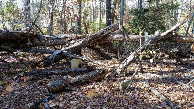
After people, one of the best resources I have for locating as many sites as possible is Google Earth. I use it to try and verify the tips received from people around the county. The biggest trouble I have run into is that some are so grown over you can’t really tell that they are even there without actually going to the site!

Arrow

There really are graves there! I promise!

Another method we’ve used is simply driving down the back country roads, places off the beaten track, and just looking around. Mostly it’s just enjoying the beautiful scenery, but sometimes we get lucky and find a great location. Additionally I would like to thank the Dorchester County Sheriff’s Office for keeping mental notes and telling me of the all the places they’ve spotted grave sites while out on their patrols.

Google Earth can also be used to try and find plots that no one has pointed out to us yet. This is the most time consuming part. Zooming in to a part of the county and then panning around, looking for something, anything that might mean grave sites.  Sometimes we are fortunate and can actually see the rows of stones on a property.

Railroad GE

  Spedden GE

Sometimes however we are simply panning around, looking for changes in agricultural patterns and then questioning the farmers on whether this is just an irrigation stop or perhaps something that warrants more investigation.

Stagecoach GE

As it happens, there actually were graves in the field shown above. That small circle in the middle of a soy bean field is someone’s final resting place.

As always, check back for more updates, but for now I’ll leave you with an interesting fact:

We have located 90 burial sites already, and haven’t even been south of
Church Creek yet!

Why are we here…?

The question I get from people most often when talking about this project is “Why?”. Apparently graveyards are not something people think about often. We go to a funeral, bury a loved one, and then move on with our lives, rarely thinking about that small stone in the ground. If you are lucky this cycle doesn’t happen often, If you are like me, it happens far more frequently than you would wish.

The answer is simple. Because. Because we are losing these sites to time and tide. Because some have no one to take care of them, because some are already past all hope of help. Because this is our heritage, our history.  Because there are so many stories out there to be told. Because these sites, no matter how small, or how old deserve the same respect and dignity of any of the large, for profit, cemeteries. Because I don’t believe anyone even knows where they are all anymore. And finally, Because if we don’t do it, who will?

Some are easy to find. They can be right in someones front yard.

DSCF3141

Some take more time and effort to find and then get to…

DSCF1745      DSCF1743

When strangers happen upon us at a burial site we get some of the strangest looks; surprise, disgust, suspicion… Cars slow down and creep by, I guess wondering why there are a handful of people in the cemetery taking pictures and holding strange electronics. After all nothing says mischief like a pair of rainbow polka dot rain boots…

boots

However we have been fortunate in our travels that there are many more people fascinated by what we are doing than repulsed by it. I was able to speak with a man who was volunteering his time to help rebuild one of the more historic churches in the county down on Taylor’s Island. In addition to a quick history of that church, he was also able to guide me to another grave site nearby and gave me a brief history of that one as well.

Sometimes curious neighbors come out and speak to me absolutely thrilled that their site will be featured in the project. I had a lovely conversation with a church elder who gave me a brief history of the church, some great facts about the neighboring historical buildings, and discussed with me the sad situation that since the church has recently been renamed, the church elders feel they have lost some of their identity. I wish I had the capability to record some of these conversations, or at least had an anthropologist on my team to know what to do with such cultural knowledge.

Always looking for volunteers.   Email us at dorchestergraves@gmail.com

Heroes and History

I wanted to dedicate an entire blog post to the Members of the Armed Forces. We have come across many, many military graves located around the county. For such a small area we have certainly produced a proud number of Soldiers, Sailors, Airmen, and Marines.

In addition to the hundreds of World War I and II service members laid to rest in Dorchester County, there are a notable number of military gravestones from Vietnam, and Korea, as well as campaigns as far back as the Spanish American War, the Civil War, the War of 1812, and even the American Revolution. The Revolution graves are usually marked with a medallion so as to be properly identified.

DSCF1999

Christ Church in Cambridge has a row of such graves. The medallion reads SAR 1775. Sons of the American Revolution.

              DSCF2220               DSCF2252

The monument on the left is for a French born sailor who served in the Spanish American War and the monument on the right is for the first man from Dorchester County to die in World War I. His ship was torpedoed off the coast of Scotland and he died on a life raft a few hours after the explosion from his injuries and exposure. He volunteered for service.

DSCF2105

This crypt is for a young man who died in Coblenz, Germany during the United States Marine Corps campaigns during World War I. A fact of note is that this is the only above ground crypt in the entire graveyard.

DSCF2179

This graveyard is the final resting place for what appears to be three brothers who all served in the War of 1812. The 1812 Service Members are also identified with a marker. Sadly no further information is available for this family. I will have to do some more research and hopefully bring more of their narrative to light.

      DSCF2482         DSCF2481

Everyone has heard the phrase “Brother against Brother” when speaking about the Civil War; Dorchester County had Father against Son.

DSCF3211

 This humble stone is the marker for Lieut. Colonel Thomas Woolford, leader of the 4th Maryland Regiment during the American Revolution. Wounded and taken prisoner in the Battle of Camden, SC, he was also part of the campaign to free Charleston from the British.

All of these stories are either amazing, heroic, tragic, or moving. They all deserve to be told. And yet, this is just a handful of the monuments around the county. This project has only covered about half of the area of the county, so there are still a great many more resting places as yet unmapped.

All of the information for these brave soldiers was gleaned from the monuments themselves or from 5 minutes on Google. If this much information was uncovered in such a short amount of time I would love to see what could be accomplished by a dedicated researcher.